The Seine’s flooding, the toll is poised to be heavy
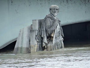 Zouave of the Alma Bridge on June 4, 2016 © Ibex73, CC BY-SA 4.0 Zouave of the Alma Bridge on June 4, 2016 © Ibex73, CC BY-SA 4.0 |
.jpg?uselang=fr)
Zouave of the Alma Bridge on June 4, 2016, the Seine's flooding climbed to 6.1 meters in Paris, the most important high-water mark since 1982. It remains, nonetheless, well behind the one reported in 1910 where water level peaked to 8.62 meters.
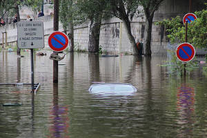
Huge material damage has been reported during the recent rainfall which claimed the lives of four people and injured another 24 persons. In total, 20 000 inhabitants had to be evacuated and more than 25 000 houses have been affected by these floods.
Land and railway traffic have been seriously disrupted. Many road arteries, including the motor way A10, have been closed to traffic for several days.
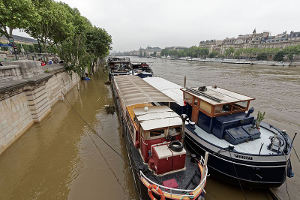
Economic and commercial centers located across the Seine have interrupted their business. River trade has come to a standstill.
Tourism, one of the hardest-hit sectors by the Seine’s flooding
Tourism has been seriously strained by these floods. The banks of the Seine, designed to host tourists, were completely submerged by water. Neighboring restaurants as well as cruise boat companies interrupted their activities for several days during the high season.
The committee for river boat owners (CAF) estimated future-lost earnings at 11 million EUR for tourist transport companies operating on the Seine river.
The amounts pertaining to operating damage continue to rise day after day, in addition to the extensive amount of time taken in the clean-up operations of the wharfs.
Located across the Seine, the Louvre and Orsay museums, have been put on a state of emergency, remaining closed to the public for four days(1). The collections located in flood-risk areas have been shifted to higher storeys.
Totalling respectively 460 000 and 3 300 works of art, these two big Paris museums have been endowed since 2002 with a prevention plan designed to address flood risks. It consists in holding simulation drills of a major flood, prompting staff to evacuate the risky areas of the museums. This plan is triggered as soon as the high-water mark reaches 5.5 meters.
Neither of the previously-mentioned institutions has sustained direct damage associated with floods. Both have, nevertheless, sustained significant future-lost earnings: 1.6 million USD for the Louvre museum and 226 000 USD for the Orsay museum.
(1) From Friday 3 rd to Tuesday 7 th June 2016
Agriculture, another important sector affected by the Seine's flooding
The agricultural sector has also been affected by floods, especially in the Loiret constituency. Major crops, vegetable production, arboriculture as well as livestock have been directly harmed by these storms. No accurate toll for the damage caused has been established so far though economic losses are poised to be quite high.
In order to be entitled to compensation, the affected farmers have claimed that the state of agricultural calamity be proclaimed, a measure that would enable them to benefit from compensations from the Fond National de Gestion des Risques Agricoles (the national fund for the management of agricultural risks) (FNGRA). No decree has so far been issued by the ministry of agriculture in this regard.
The state of natural disaster
 © Djielle, CC BY-SA 4.0 © Djielle, CC BY-SA 4.0 |
On June 8, 2016, the ministerial cabinet proclaimed the state of natural disaster for the 780 municipalities located in 16 constituencies. An “exceptional support fund” has been established with a view to indemnifying the hardest hit people immediately. The settlement of the compensations by insurance companies will come at a later stage.
The 2016 Seine's floods, one of the most onerous claims for France
According to some professional sources, insurers have received, since June 16, 2016, 120 000 claim notifications following these floods. An initial estimate, established by the French insurance association, set the losses between the bracket of 900 million EUR to 1.4 billion EUR. Half the amount of which would be borne by the Caisse Centrale de Réassurance (CCR).
The 2016 floods are likely to cost twice those that washed southeast France in October 2015(1) and may stand as the most costly claim since the institution in 1982 of the natural catastrophe coverage.
The natural catastrophe guarantee: “Cat Nat”
Established by the 13 July 1982 Law, the “Cat Nat” plan has been designed to cover citizens (private individuals or professionals) against the risks of natural catastrophes (flooding, landslides, earthquakes, cyclones, storms, volcano eruptions, forest fires, droughts, etc.), providing them, in the event of one of these calamities, with timely compensation that is proportional to the scale of the damage sustained.
This cover is mandatory, and granted for non life insurance contracts (comprehensive homeowner's, comprehensive business, motor).
Such schemes come into force only after the state of natural disaster has been proclaimed by authorities. In this situation, the victims have to report their claim within ten days, at the latest, from the publication of the ministerial order in the national gazette.
(1) 600 million EUR (656 million USD) for 65 000 claim notifications
Insurance code. Article L. 125-1:
««Non insurable direct material damage the determining cause of which was the abnormal intensity of a natural agent, when normal measures taken to avoid such damage have been unable to prevent the occurrence thereof or could not be taken, shall be deemed to be a natural disaster»».Ile de France, a flood risk-prone area
 The Seine’s floods in Paris © Thesupermat, CC BY-SA 4.0 The Seine’s floods in Paris © Thesupermat, CC BY-SA 4.0 |
Ile de France is an area that is extremely exposed to flooding. The lessons drawn from the January 1910 and 1924 floods, which paralyzed the French capital for several days, have been well learned.
Ever since, several measures have been initiated in order to minimize the consequences of the Seine’s overflowing: raising bridges, digging and deepening of the riverbed, building of dams, etc.
These works have greatly regulated stream flows crossing the region. Experts estimate that these undertakings have managed to reduce the level of the Seine by about 70 centimeters.
The level of the Seine is officially measured by a graduated scale set up on the Austerlitz Bridge. The zero point of the scale corresponds to 25.92 meters. In ordinary times, the level of water is around the zero grade.
Paris dwellers rely on a less accurate indicator to measure the level of the Seine river: In ordinary times, the Zouave feet(1) of the Alma Bridge(2) should be dry whereas at the beginning of a flood, the feet are in water. At the peak of the major 1910 flood, the water level reached the shoulders of the statue.
The most important Seine’s floods, from 1900 to 2016
| Date | The Seine level |
|---|---|
| June 2016 | 6.1 m |
| January 1982 | 6.13 m |
| January 1959 | 6.2 m |
| January 1955 | 7.1 m |
| January 1924 | 7.3 m |
| January 1910 | 8.62 m |
Source: Weather chronicle from 1900 to-date (1)Zouave is a stone statue of Georges Diebolt dating back to 1856, one of the four sculptures representing the troops that took part in Crimea war. This statue is located under the Alma Bridge in Paris
(2)The Alma Bridge is a Paris bridge across the Seine. Its name is a reminder of the Alma Battle (1854) in Crimea
Read also: