Natural disasters in the United States
 Cyclones and floods on the East coast and in the Gulf of Mexico, tornadoes in the Midwest, fires and earthquakes on the West coast; major US coastal cities, Los Angeles, San Francisco, Miami, New Orleans, Houston, New York,... are often affected by natural disasters such as earthquakes, cyclones, fire, and snowstorms.
Given the large number of inhabitants in these areas and the concentration of material goods and industrial infrastructures, the damage caused has a considerable financial impact, with insurers and reinsurers paying a heavy price.
In the United States, an event is characterized as a disaster when:
- claims reach a certain threshold, currently set at 25 million USD,
- a certain number of policyholders and insurers are affected by the event.
Level of exposure to natural disasters in the United States
The United States is one of the countries with the highest level of exposure to natural disaster in the world. The Gulf of Mexico and the Northeastern coast of the United States are regularly hit by strong cyclone activity.
The West coast and California in particular are exposed to earthquake risk, while the central region of the country "Tornado Alley" is annually impacted by tornadoes.
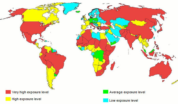
Source: European Journal of Geography
Related article: Coverage of natural disasters in the United States
Natural disasters in the United States: Exposure to Hurricanes
Tropical depressions originate in the oceans, in the intertropical zones. These events go through two stages of life before reaching their extreme intensity to be granted the name of hurricane.
There are three levels of depression intensity:
- Tropical depression: maximum wind speed less than 63 Km/h,
- Tropical Storm: wind speed between 63 km/h and 117 km/h
- Hurricane, typhoon or cyclone: wind speed exceeds 118 km/h with formation of an eye in the center of the depression.
By reaching level three, tropical storms are then called hurricane, typhoon or cyclone depending on the region of their occurrence
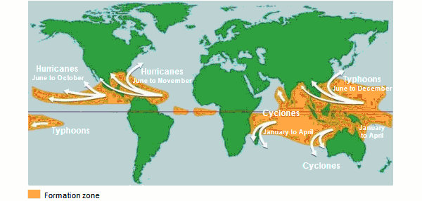
The different denominations of tropical depressions per basin:
- Hurricane in the North Atlantic and Northeast Pacific,
- Typhoon in East Asia,
- Cyclone in the South Pacific and the Indian Ocean.
Natural disasters in the United States: Exposure to Tornadoes
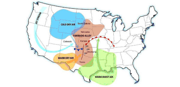
It is in the Central American Great Plains region that tornadoes mark a corridor that runs from Texas to North Dakota, that is from the Gulf of Mexico to the Canadian border. The geographical delimitation of the Tornado Alley is variable but with only one certainty: it is in the center of the country, far from the East and West coasts of the United States, that this phenomenon originates. The formation of tornadoes in this region is favored by the encounter of cold air masses coming from Canada with two currents rising from the South, hot and dry air from the Southwest and the hot and humid current from the South-east.
The States of Oklahoma, Kansas, Arkansas, Iowa and Missouri that are in the eye of the Tornado Alley are the hardest hit by this type of natural phenomenon.
The United States accounts for an annual average of 800 tornadoes, twenty of which are extremely violent, reaching categories 4 and 5. The latter are particularly destructive and deadly. Tornadoes claim the lives of approximately 150 people per year and cause tens of millions of dollars in damage. It is during the period between March and May that tornado activity peaks.
Source: wikipedia.org/wiki/Tornado_Alley
Natural disasters in the United States: Exposure to Forest Fires
The American West is exposed to ravaging fires. Forest fires are on the rise, especially in California, a State known for its Mediterranean vegetation. The area destroyed by fire has more than doubled since 1984.
This increase in fires has been accounted for by global warming, which increases the frequency and intensity of fires.
Top 10 most expensive fires in terms of insured losses
Figures in millions USD| Rank | Year | Name | State | Estimated insured losses |
|---|---|---|---|---|
| 1 | 2018 | Camp Fire | California | 10000 |
| 2 | 2017 | Tubbs Fire | California | 8700 |
| 3 | 2018 | Woolsey Fire | California | 4200 |
| 4 | 1991 | Oakland Fire (Tunnel) | California | 1700 |
| 5 | 2017 | Atlas Fire | California | 3000 |
| 6 | 2020 | Glass Fire | California | 2950 |
| 7 | 2020 | CZU Lightning Complex Fire | California | 2500 |
| 8 | 2017 | Thomas Fire | California | 2250 |
| 9 | 2020 | LNU Lightning Complex Fire | California | 2250 |
| 10 | 2007 | Witch Fire | California | 1600 |
Discover our article on wildfires in California
Natural disasters in the United States: Exposure to Earthquakes
The West coast namely California presents an extremely high earthquake risk. The seismic activity focuses mainly on the 1300-kilometer San Andreas Fault stretching from the South of Los Angeles to the North of San Francisco. Other seismic zones are in San Francisco Bay (Hayward Fault), Hawaii, in Alaska, and to a lesser extent in Nevada, Missouri, Kansas, Oklahoma, and Virginia.
Seismic risk poses a real threat to more than 143 million resident Americans in 39 States, mostly located in the Western part of the country.
The last major earthquake which hit the U.S with a 6.9 magnitude, took place in San Francisco in October 17, 1989. The earthquake killed 63 people and injured 4000 others. More than 20 000 homes were destroyed causing damage estimated at ten billion dollars.
The multiple research and data compiled predict the occurrence in California in the coming years, of a major earthquake, of magnitude greater than or equal to 6.7 on the Richter scale, the "Big One".
American earthquake risk map
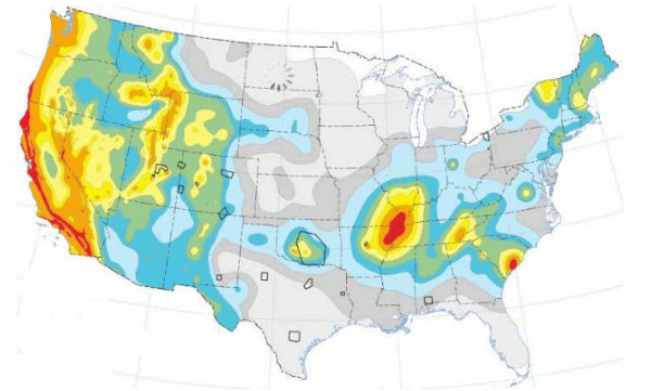
Source: United States Geological Survey